Since childhood I'd had a mental image of an aquifer as a big underground lake, but it turns out that's not so accurate. Aquifers are layers of permeable rock or ground-up rock (dirt, silt, etc.) below the earth's surface that contain groundwater. When we sink a well down to water, we're trying to extract water from an aquifer. Any time you hear about groundwater usage (as opposed to surface water usage) you should think "aquifers!"
Why care about aquifers? Well, I like to drink water. When I visited Charleston, South Carolina and Savannah, Georgia this spring I learned that many wells in the region have been rendered useless because of saltwater intrusion -- if you pump out fresh water and you're near the coast, salty water comes in! Also, I would like it if my house did not collapse into a sinkhole. Apparently in 2010 about 130 sinkholes appeared in Florida, because of rapid removal of water from aquifers. That water in the spaces in the rock is pretty important. Last of all, many people enjoy lakefront property and recreation. The site just linked is for the White Bear Lake Restoration Association. Why does White Bear Lake in Minnesota need a restoration association? Because it's been shrinking dramatically, and now the docks are on dry land and lakefront property isn't on the lakefront any more. The US Geological Survey (USGS) and Minnesota DNR have concluded it's because of the draining of an aquifer that has contact with the lake.
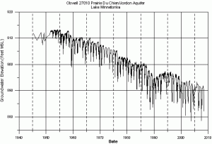
Alright. We like drinking water, not falling into sinkholes, and waterskiing rather than trudging through muck. How, then, do scientists look at aquifer health? One way to do this is through keeping track of well levels across a region and coupling that data with geological information about aquifer locations. The graph of water level for a well is called a hydrograph, and this one is shared directly from the Minnesota DNR page with their permission:
The USGS maintains a groundwater watch page from which you can find all sorts of data for your local wells, and many states maintain similar pages. I used the Minnesota Water Level Monitoring Page to find the raw data for the above well, and then used the R program to create graphs for this worksheet on rate of change.
You'll notice a huge seasonal variation in well depth. Groundwater is commonly used for industrial applications, which may be year-round, but also for agriculture and lawn care, which are seasonal. According to one source, the city of Woodbury in Minnesota pumps around 5 million gallons a day in winter and 20 million gallons a day in summer.
This worksheet looks at real, messy data. Students are asked to estimate a lot of numbers and discuss their estimates with group members and the instructor. It's a good time for discussion of estimates and how we deal with real, messy data -- shill for your local statistics class here! The worksheet covers:
- graphical approximation of average rate of change,
- graphical approximation of instantaneous rate of change,
- creating a linear model using approximations of rate of change,
- and analyzing the model.
The graphs take up a lot of room but the questions are pretty straightforward, so print it double sided and it won't take that long to do in class. Have students work in groups and ask different groups to report their results by writing them on the board: they will have different numbers and can discuss the validity of each approximation. The last question, in particular, is open for a lot of debate: what does it mean for a well to "run dry" if there is seasonal variation in water level?
Rate Of Change: Aquifers worksheet
Oh, if you've forgotten, remember we're still under federal budget sequestration: the USGS is going to have to turn off a number of streamgages used to monitor stream health and warn of flood events because it can't afford to keep them going...

